This company makes maps of the ancient world the way it was “back then.” This is especially important helping us understand where our ancient ancestors lived. I believe we must rethink all archaeology. We know we are leaving out the lives of the peoples who lived along the shorelines because today those same shorelines are under water in many places.
Just too cool and so wonderful – I am crawling around their website and wish wish wish they would send me a free map that could be my ‘feature image” for this blog story!
Go here and look at all their wonderful research and great work to help us find the places where our ancient ancestors lived!
The website does not say where to findthe map showing the shorelines that are now under water, and the Discover Magazine article does not say which map this is. But this is THE site to look at, to think about the archaeology of yesteryear and how we might support the underwater archaeology!
This great map from Science Magazine shows some sites where Neanderthals were living. We know if it was a good place then to live for them, the modern humans who replaced them might have lived there also. And we can see from Deep Time Map here where we might begin searching under the water!
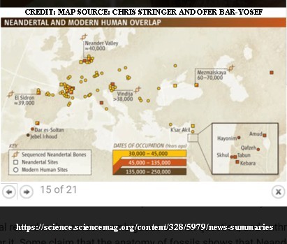
This map is shared in this story:
PALEOGENETICS
Close Encounters of the Prehistoric Kind
- Ann Gibbons
The long-awaited sequence of the Neanderthal genome suggests that modern humans and Neanderthals interbred tens of thousands of years ago, perhaps in the Middle East.
https://science.sciencemag.org/content/328/5979/news-summaries
Between satellite searches for signs of ancient locations and a better understanding how shorelines have changed, we should begin to find more and more of our own history – AND Herstory!

Lascaux IV Museum illustrates what the landscape looked like at the presumed time the cave art was created. Photo CLKJ
