Update: I had a message from a reader who tells us about another map of interest.
I add in the Library of Virginia there are letters that list the writer as being from “Hanover Town” 1807. This first map shows Hanover Courthouse where Hanover Tavern was across the road. Page’s warehouse and possibly the location where a town of Hanover – Hanovertown – might have first been proposed is farther down the road where the Civil War encampment is mapped and also a historical marker still stands. I wish the reader had shared the comment via a method so that I could share it, but I can’t.
Being there is a historical marker at the location of Page’s Warehouse and Hanovertown these locations are well documented. There are also the historical markers of the community of Hanover Courthouse, Hanover Tavern and there are 1807 letters stated being at the Courthouse community. And it is called Hanover Town by the Library of Virginia.
http://www.virginiamemory.com/transcribe/items/show/17206
In 1807, it was not an official town as such, but “Hanover Town” was the name. The reader suggests another map from 1820 – I will get it and share it! Excited to do so. And also hope to find the 1807 ear maps. We have visited Hanover Courthouse, Tavern and Pages and the farms and historical marker many times as well as the Library of Virginia. We are over due for a visit back.
These maps are from Googling and are Google and Mapquest and the library of congress – the links are all hopefully working
And there are at least four men named John Lewis who lived and died in the York to the Anna Rivers valleys. So – can more be figured out to ID our John Lewis? These are locations and neighbors – once more for the choir!
More and more I hope we will add name after name on the lands
Hanover town Virginia is said to be the location of where Page’s Warehouse was located. The writer of the book about the civil war made a mistake.
The place of encampment during the civil war was the place that was the original Page’s Warehouse aka Hanovertown. The “new” Hanover Town with its 1734 built Court House is up the road from Hanovertown and across the road from Hanover Tavern. (Perkins store is still not confirmed.)
Wikipedia for Hanover town
“2… Cold Harbor: Grant and Lee, May 26-June 3, 1864 By Gordon C. Rhea p 43 https://books.google.com/books?id=a4xM5ZixENMC&lpg=PA43&ots=pSTMmDhf9j&dq=%22Page’s%20warehouse%22%20hanover&pg=PA43#v=onepage&q=%22Page’s%20warehouse%22%20hanover&f=false “originally known as “Page’s Warehouse, hanovertown in colonial times had been the Pamunkey’s highest transshipment point for tobacco awaiting transportation downriver”…”
https://en.wikipedia.org/wiki/Hanover_Town,_Virginia
The Jefferson Fry Map

https://www.loc.gov/resource/g3880.ct000370/
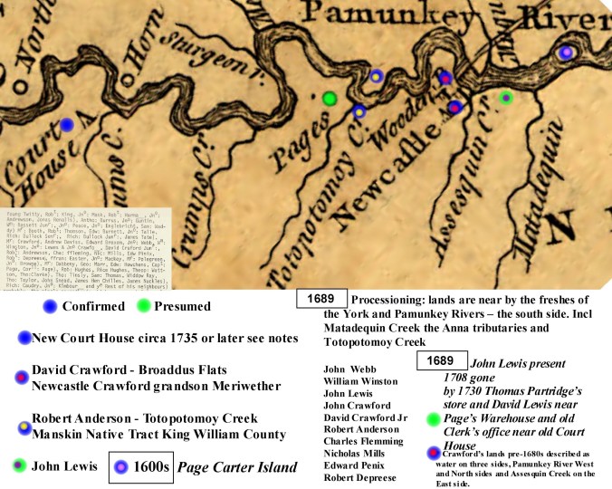
Crawford and Meriwether are near Totopotomoy Creek 1690

Enter a caption
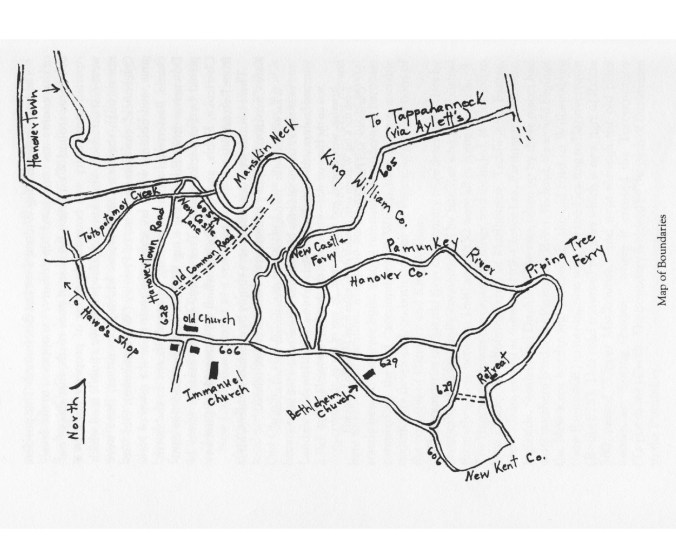
This USGS map locates TOTOPOTOMOY creek and where it meets the river and places Page’s at the site of historical marker for the civil war.

Page’s at the curve
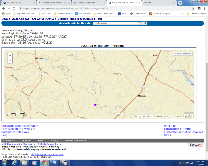
TOTOPOTOMOY creek
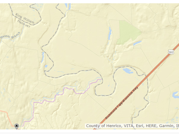
TOTOPOTOMOY creek is highlighted in the line of purple below the map line of the creek. It shows where it meets the river and the Crawford Meriwether etc lands were near these spots. From the previous we know the locations of Page’s and his neighbors
https://waterdata.usgs.gov/va/nwis/nwismap/?site_no=01673550&agency_cd=USGS
The old Hanovertown marker and the location are both on private property and cannot be viewed from the road.
| Virginia (Hanover County), Studley — “Hanover Town” — |
| Site of Old Forte Matuxon, dismantled in 1676 by Major John Page. Page’s Warehouse, port of entry and export, established by Matthew Page long prior to 1734. Town incorporated November 1762. Competed with Richmond for capitol of Virginia. — — Map (db m54756) HM | |||
“Hanover Town”

Inscription.  Site of Old Forte Matuxon, dismantled in 1676 by Major John Page.
Page’s Warehouse, port of entry and export, established by Matthew Page long prior to 1734. Town incorporated November 1762. Competed with Richmond for capitol of Virginia.
Erected 1929 by Hanover Branch A.P.V.A.
Location. 37° 41.838′ N, 77° 14.743′ W. Marker is in Studley, Virginia, in Hanover County. Marker can be reached from River Road (Virginia Route 605) 0.9 miles east of Summer Hill Road (Virginia Route 644). Touch for map. Located on private property and can not be viewed from the road. Marker is in this post office area: Studley VA 23162, United States of America. Touch for directions.
Other nearby markers. At least 8 other markers are within 3 miles of this marker, measured as the crow flies. Hanovertown(a few steps from this marker); Union Army’s Crossing of the Pamunkey River (a few steps from this marker); William Latané (approx. 0.8 miles away); Stuart’s Ride (approx. 2½ miles away); Nelson’s Crossing(approx. 2.8 miles away);
. Click for full size.")
Salem Church/Haw’s Shop (approx. 2.9 miles away); Studley (approx. 3 miles away); Early Airmail Service (approx. 3 miles away). Touch for a list and map of all markers in Studley.
Categories. • Forts, Castles • Settlements & Settlers • Waterways & Vessels •
Taken: April 21, 2012
Caption: Site of Hanovertown on the Pamunkey River (private property)
Submitted: April 23, 2012, by Bernard Fisher of Mechanicsville, Virginia.
Database Locator Identification Number: p201431
File Size: 0.915 Megabytes
Credits. This page was last revised on June 16, 2016. This page originally submitted on April 23, 2012, by Bernard Fisher of Mechanicsville, Virginia. This page has been viewed 1,318 times since then and 71 times this year. Photos: 1, 2. submitted on April 23, 2012, by Bernard Fisher of Mechanicsville, Virginia.
https://www.hmdb.org/marker.asp?marker=54756
SEE BELOW note:
Neighbors 1709

By 1708 John Lewis ??? Our ??? John Lewis??? With David Crawford as neighbors. We can place Crawford on a map
| Genre/Form: | History |
|---|---|
| Named Person: | Crawford family; Broadus family; Broadus family.; Crawford family. |
| Document Type: | Article |
| All Authors / Contributors: | Tom Hobbs
Find more information about:
Tom Hobbs |
| OCLC Number: | 669986037 |
| Notes: | Includes ill. and maps. Portions of Broaddus Flats were formerly known as Assassquin Plantation and Woremeley’s Field. |
To figure out each place build maps

website cannot be located
This map shows the new and old towns
If a Lewis property was then near Page’s Warehouse – as it is even called in the vestry books and if the original David Crawford track was just near Page’s and Lewis was by him and Nicholas Meriwether then…
About Crawford “Assassquin Plantation” south – Broaddus Flats – The History of the Broaddus Flats Site (44Hn254)”: “David Crafford (also Crawford) had purchased 1,316 acres … The History of the Broaddus Flats Site (44Hn254) – Assassquin Plantation.
The dig at the Crawford place
https://www.hanoverhistorical.org/recenteventsnative.html

So much is written about these early Europeans – Notes from three pages of June Banks Evans

Crawford
http://objgenealogy.com/indiI2637.html
Crawford
the LATER – Hanover
http://genealogytrails.com/vir/hanover/
note:
Today Hanover town/city the location of the Tavern and the court house are not where they were originally. They were not beside the river and should not be where we look for our Lewis and Crawford families with our associated neighbors Meriwether etc
The move in about 1733 through 1734
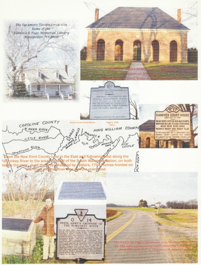
A license for a tavern at Hanover Courthouse was issued in 1733. When William Parks, editor of the Virginia Gazette, purchased Hanover Tavern in 1743, it was part of a 550 acre plantation at the courthouse. Today, Hanover Tavern occupies a site consisting of 3.5 acres.
https://hanovertavern.org/tavern/history/
https://www.hmdb.org/map.asp?markers=53801
Also with names and locations of property for mapping
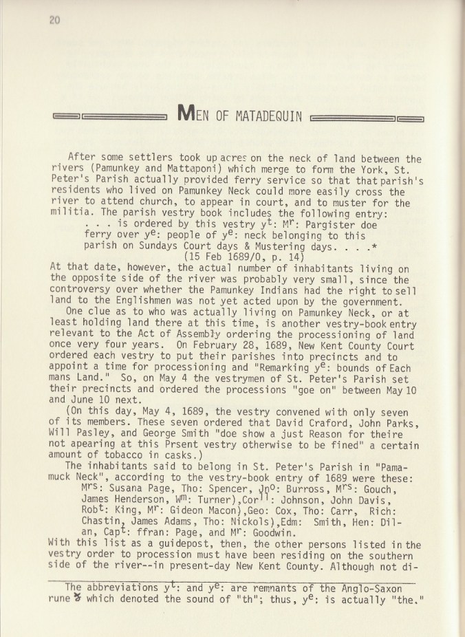
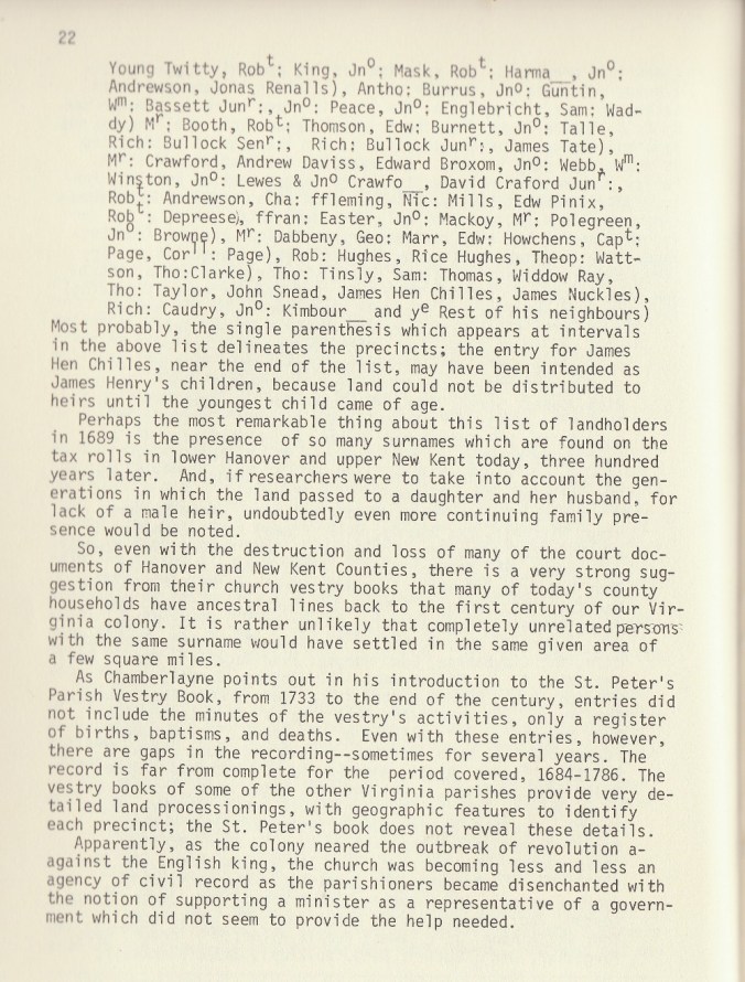
Men of Matadequin June Banks Evans
https://books.google.com/books/about/Men_of_Matadequin.html?id=aoxXswEACAAJ
Locations King William County this has great home descriptions and some locations
http://genealogytrails.com/vir/kingwilliam/county_history.html
Broaddus – order Tom Hobbs books
Broaddus Flats Overview
The Broaddus Flats Site (44Hn254) is a multicomponent (colonial, prehistoric and contact) site located near the south bank of the Pamunkey River in northeastern Hanover County.
Originally within New Kent County, this home may have been Assesquin Plantation, home of family patriarch David Crafford (also Crawford). (For more information, see “The History of the Broaddus Flats Site.”)
Excavations over nine years have revealed partial brick foundations, a cellar and a slot trench for a posted fence that enclosed the half-acre yard.
Ceramic finds include English delftware, Rhenish and English stonewares, imported and locally-made earthenwares. Marked pottery by William Rogers of Yorktown and plain Colono-ware are also well-represented. English pipe bowl styles range from the 1690s to about 1740, with an abundant sampling having maker’s marks within cartouches from the first quarter of the 18th century. (For more information, see “Artifactual Evidence from the Broaddus Flats Site.”)
Faunal remains indicate a varied diet of both domesticated and wild game.
by Tom Hobbs
“Prior to the birth of Hanover County, Virginia (1721) the entire region just north of Richmond was New Kent County, one of the early counties (1654) founded in the mid 17th century by Englishmen expanding settlements and “hundreds” away from Jamestown. Although New Kent’s eastern boundary was established at about Ware Creek and the western edge of James City County, early records are unclear exactly where its western boundary was—presumably, the Monacan Indian empire or even the Blue Ridge Mountains. Regardless, by the middle of the 17th century, only a handful of brave settlers built homes west of Virginia’s fall line and into New Kent’s western frontier. Enterprising gentlemen, such as John Page, preferred to own land ‘on the upper freshes of the Pamunkey River,’ where indentured servants tended his tobacco fields, but he lived in Middle Plantation (later renamed Williamsburg). Even though Page and many other “gentlemen” of the era were “cittie” dwellers, most owned at least a few hundred acres of farmland in the hinterlands or even farther out into the frontier. Most were also expected to participate in all aspects of colonial life, including an Anglican Church office, such as vestryman or warden, and / or to hold a commission in the local militia. Page, for example, is often recorded as “Col. John Page, Esq.”
It was, therefore, a little surprising to me to discover the substantial remains of a late 17th century home so far west of settled areas in eastern New Kent County. Because this part of Virginia was still in a “contact period” between Native Americans and Anglo-American settlers, it was not surprising to me to find Indian pottery and pipe parts in the same context with colonial artifacts. It must be pointed out, however, that Native Americans undoubtedly lived on the flat terrain adjacent to the Pamunkey River for thousands of years, and that they might not have been anxious to abandon these fertile hunting and farming grounds to European “persisters.”
The 1995 discovery of a 2.5’ wide (and about the same depth from colonial ground level) trench on the site’s south side puzzled me and my archaeology friends. Over a period of four years we have carefully excavated about 50’ of it and have uncovered deep-seated posts (5″ x 7″) spaced every 8’ down the center. These now appear to have been support posts for a substantial wall, possibly for the defense of the house and its outbuildings. Some additional careful archeology on the “inside” diagonal edge of the V-shaped feature revealed evidence of two burned posts (so far) representing, we think, supports for a “cat walk” or platform along that side of the wall. This feature would allow someone to peer over the wall or look through gun slots cut into the wall.
Indeed, defense was foremost on the minds of these frontier settlers—only about twenty years prior to the 1690’s a concerned farmer named Nathaniel Bacon had fomented a rebellion against Governor William Berkeley over several issues. One of these was a concern over the governor’s participation in a lucrative trade with the Indians of outlying counties and his apparent disregard for mounting commercial (tobacco-growing & trading) problems and for protection against hostile Indians. At any rate, it seems that the governor was either unwilling or unable to raise and support an army large enough to protect an ever-growing colony of land-hungry, lower-class tobacco farmers. So, it appears that settlers along the ‘upper freshes of the Pamunkey’ were pretty much on their own to ply their trade and to protect their commercial and domestic holdings as best they could. To complicate matters more, Bacon complained to Berkeley that English indentured servants were not receiving the opportunities promised to them with the successful completion of their indenture. How these second-class citizens of 17th century Virginia protected themselves and their families is a matter for discussion elsewhere. Bacon and his militia, in the meantime, marched on Jamestown and burned the Statehouse to the ground. Berkeley fled to safer ground.
In addition to the above-mentioned worry, frontier colonists became increasingly aware of the influx of convicted felons, often fresh out of Newgate Prison in London, into Virginia’s and Maryland’s Tidewater counties. Most of them became ballast (literally) for west-bound ships, were committed to a seven-year indenture once in the colony, were banished from England forever, and did not receive the same “freedom dues” that other servants got at the close of their indenture. Apparently, many of these felon servants, both men and women, got into scrapes with the Law and with their masters. Colonial records describe them variously as ‘desperate villaines’, ‘jaile birds’, and ‘wicked convicts.’ Some ran away to other counties or even to neighboring colonies, where they were thought to have perpetrated acts of violence and sabotage. One such event occurred on April 1, 1729, when members of the King’s Council in Virginia advised the governor that the Westmoreland County home of Col. Thomas Lee had been burned to the ground by persons unknown. Governor Gooch investigated and reported that ‘the recent outrage can be attributed to the secret Robberies and other villainous attempts of a more pernicious Crew of transported felons.’ The House of Burgesses had tried in 1670 to halt the flow of convicts with their Jaile Bird Act but this law must have fallen on deaf ears in Parliament. The author feels that the rumors and official reports of these acts alone would induce a plantation owner in rural New Kent (later Hanover County) to build a wall around his dwelling house and outbuildings.
Further evidence for self-protection or participation in a militia can, I think, be deduced from some of the artifacts uncovered in the past ten years at 44Hn254. Flintlock gun parts and “used-up” gunflints are a fairly common find on the site.
In 1999 students found the iron frissen to a flint-lock pistol and an iron sword pommel to a 17th century rapier, a type of sword worn by officers and gentlemen of the day. These weapons were not being used for hunting wild game, however, the larger gun flints were most likely from “fowling pieces,” used for doing just that. Also, the greater percentage of excavated faunal remains (bones) should be from those animals, however, an examination of the food remains excavated from the principle trash pit, the 9’ X 20’ cellar, reveals that the vast portion of bones are from domesticated animals such as cow and pig. (They also had a healthy appetite for oysters ! ) Further possible connection to participation in a militia by the man of the house was suggested to the author on a trip to Williamsburg several years ago. Ivor Noel Hume, retired archaeologist for The Colonial Williamsburg Foundation, identified some fancy brass buckles from the house site as ‘quite possibly from the hat bands of the type worn by militiamen of the 17th century.’ Jamestown Rediscovery archeologists have in recent years unearthed similar buckles from the fort area there, so it appears that this style of hat was popular throughout the century.
Records for both New Kent and Hanover counties are scarce for this turn-of-the-century period and maps are non-existent. Major portions of Hanover’s records have been destroyed by fire twice in its history. Once during the Revolutionary War, British campfires were kept lit, so the story goes, with these nice, dry manuscripts by marauding soldiers under the command of Colonel Bannastre Tarlton. Eighty years later, concerned Hanovarians did not want the same thing to happen to the county’s records at the hands of the Union Army, so they were sent by wagon into Richmond ‘for safe-keeping.’ There, of course, they were mostly consumed in the great fire started by Confederates before the city fell to Federal forces in April, 1865. For obvious reasons, not a great deal of effort was made following the War to ask residents of New Kent and Hanover to relate to county officials who had owned their property in past years, not to mention about buildings long-since gone and forgotten. A horde of old papers and documents recently found in the basement of Hanover Courthouse may one day shed some light on early landholdings of the county.
County records, fortunately, were not the only ones kept during this turn-of-the-century period. Many parish records survive from this era, including St. Peter’s of New Kent and St. Paul’s of Hanover. Unhappily for the researcher, these records tend to deal with trivial (to us now) church matters, such as who tithed how much and sometimes where these monies were allocated. I have been able to glean some enticing information, like which men owned the larger portions of land within that parish and therefore tithed the most. These records do not, however, mention exactly where their lands were, other than to say ‘the lands adjacent to so ‘n’ so’s property’ or ‘land lying on such ‘n’ such creek.’ Names of plantations are never mentioned. William Waller Hening compiled all the laws made by the General Assembly for the period 1619–1792 into thirteen volumes and, while they are useful, a more reliable source can be found in N.M. Nugent’s “Cavaliers and Pioneers: Abstracts of Virginia Land Patents and Grants.” Volume Two: 1666-1695 is particularly helpful because of the recently-granted lands on the ‘upper freshes of the Pamunkey River.’
All of these records mentioned above have strongly suggested early ownership of this large parcel of land now known as Broaddus Flats by a few gentlemen and even a lady of the late 17th century. Today, some of the low ground in which site 44Hn254 is located still bears the old name “Woremeley’s Field.” This undoubtedly is a reference to Ralph Wormeley, Esq. of Rosegill Plantation in Middlesex County on the Rappahannock River. Wormeley was on the vestry of the local Anglican church, served on the royal governor’s Council for many years, was acting governor for a while, and had vast holdings throughout upper central Virginia. Some of his land, for instance, became King William County (just north of the Pamunkey River) later in the 1730’s. Mr. Wormeley had some competition for property in New Kent County, however, and one record shows that a large parcel of the 4,000 acre Broaddus Flats was known as Assassquin Plantation by the last quarter of the 17th century. The earliest grants, probably beginning in the 1650’s, went to Sir Phillip Honeywood, William Taylor, John Sleeman (or Fleeman), Thomas Glass, Mrs. Hannah Clark, George Phillips, Andrew Davis, and to the west (near Totopotomoy Creek) the 3,000-plus acre tract known as “Mehixton” of Col. John Page. I may have found the earliest house, called Mehixton by Col. Page, in 1978 when exploring Summer Hill property with its owner, Mrs. Ruby Newton. This site, now a nearly-filled basement measuring 42’ x 24’, has been recorded at DHR with the title 44Hn94. I took students to the site for archeological excavations until the discovery of Broaddus Flats site in 1992.
By the 1680s, one sees a sort of “second wave” of westward-moving planters in this part of New Kent; names such as Poindexter, Crafford, and Meriwether. A short search of the records finds a George Poindexter (1627-1690) who emigrated to America about 1657 and acquired land in Gloucester County (north side of the York River) in March of that year. He soon built a house near Middle Plantation, probably in York County (northeast of Williamsburg), and called for his wife & family to come from England. He apparently acquired by headright a few hundred additional acres (fifty / person) for their transport to the colony. Three of George P., Sr.’s children, George II (b. 1651), John (b. 1652), and Elizabeth (b. 1654) were, according to York Co. records, given gifts of a horse and a cow by their uncle, Peter Efford, in 1664 and 1665. George P. II purchased 850 acres of land near Middle Plantation from Edward Thorp in 1667 and must have soon moved up in the ranks of young, aspiring planters. In 1679 George P. II helped establish (along with Col. John Page) Bruton Parish in Middle Plantation. George P., Sr. saw opportunity to the west and purchased land in New Kent County, where he built the brick & timber home “Christ’s Cross” (now known as Crisscross) in 1685. (There is some evidence that because of his participation in Bacon’s Rebellion and his aid to Governor Berkeley, George P., Sr. was awarded lands west of Middle Plantation in New Kent Co.) George P., Sr. was soon elected to the vestry of St. Peter’s Parish but apparently declined for poor health. The records are unclear but he probably died in 1690 and his wife, Susanna, in 1693. In 1704 George P. II was elected vestryman and served as churchwarden in 1705 and 1706. His youngest son, Thomas (1675-1719) would soon play an important role in helping ally, by marriage, three families of New Kent.
George P. II served on the vestry (and probably did business with) a certain David Crafford (also Crawford), who had purchased 1,316 acres of farmland from George P., Sr. in 1682. Crafford’s oldest daughter, Elizabeth, married Col. Nicholas Meriwether; his youngest daughter, Sarah, married Thomas Poindexter. Book #7 (1679-89) in Richmond’s Land Office records the following acquisition by David Crafford:
“Francis, Lord Howard … with the consent of the Council … do grant unto Mr. David Crafford … 1300 acres … in St. Peter’s Parish, within county of New Kent…beginning on a bank of York River at the mouth of Assaquin Run…first granted to Hannah Clarke by patent bearing date of the 10th of Feb., 1652, and by her death was…and by deed from Wm. Taylor unto David Crafford, 4th Nov. 1685.”
Mary Callaway Jones, in her extensive research of the Crafford family, reports that David Crafford was born in 1625 in Ayrshire, Scotland, immigrated to Virginia in 1643. He was married in James City County in 1654 (wife’s name unknown), built Assassquin Plantation sometime after 1685, served for a time as a Burgess from New Kent County, and was ‘killed by the Pamunkey Indians’ in 1710.
In 1693, the Meriwether’s son, William, was given a 400-acre tract by his grandfather, David Crafford—part of his farm called Assassquin Plantation. In 1730, according to Hening, Meriwether laid off 40 acres of this property for a tobacco warehouse on the Pamunkey River and shortly afterwards a town, which he called Newcastle. It was surveyed by Patrick Henry’s father, John, into half-acre lots with six streets parallel to the river and three leading down to the large commons adjacent to the river. The 52 lots apparently sold quickly, with Meriwether taking a full acre lot by the commons. In 1740, the Virginia General Assembly gave the power to William Meriwether and three other “Justices of Hanover” to build a bridge 12 ft. wide from Newcastle over the Pamunkey to King William County—the first bridge to span a tidal river in the thirteen American colonies.
Although the location of the town of Newcastle is well known today, nothing remains of its earlier splendor when, in the mid-18th century, it was seriously considered to be the new Virginia capital. Richmond won out in that race; towns such as Newcastle and Hanovertown (old Page’s Warehouse located a few miles up the Pamunkey) became ghost towns as the century wore on. A short study of the USGS Quadrangle map containing Broaddus Flats quickly reveals that Assassquin Plantation was bounded on three sides by water—on the west and north by the Pamunkey River, on the east by Assassquin Creek, and on the south by a steep 90 ft. gradient leading up to the flatlands of Old Church.
The answer to the question “Who could have built this structure ?” is now fairly clear in the author’s head. Taking into account its location, its probable date of construction (1680’s or 1690’s), and who would have had the means to build a home of this size (42’ x 21’ with a “kitchen wing” measuring 32’ x 17’ to the north), the author feels sure we have been excavating the David Craffordfamily seat of Assassquin Plantation. Since discovering an early 18th century pewter button with initials “TP” (Thomas Poindexter ?) a couple of years ago, it is quite possible that this structure passed on to the Crafford’s daughter, Sarah, and her land-rich husband, or that he lost a button while visiting his wife’s homestead.
Once again, a gap in the Hanover records obscures any motive for the Craffords, Poindexters, and Meriwethers to sell their properties in Broaddus Flats in the mid-18th century. The Crafford name seems to disappear altogether, probably because any male children did not survive and the female children married. By the 1760’s several counties west of Hanover, such as Goochland, Louisa, and Albemarle had established courthouses and local governments; familiar names suddenly appear on the new vestry and militia lists there—Poindexter, Meriwether and Crafford (by now Crawford). The Crawfords even moved out of Virginia, to South Carolina, Alabama, and Georgia, where George W. Crawford was governor (1843-47).
The plantation house at Assassquin burned about 1740 (reference only in archeological context) and this large acreage was soon subdivided. New names such as Braxton, Syme, Tomlin, and Blakey appear on the rolls of planter elite by the early 19th century. Although adjacent to the large holdings of 19th century agronomist Edmund Ruffin, site 44Hn254 was not actually part of his tract in Hanover County. This “river field” and another, now called the “middle field,” appear to have been subdivided among six families in the mid-19th century. County records reveal that Rowland Broaddus, grandfather of the present owner, purchased all these river-front farmlands from all six owners about 1890.
It is impossible to say when or even if the old home site was pilfered for useable materials. There has been a strange lack of brick, particularly whole bricks, on the site. This is especially puzzling in light of the presence of three subterranean footings for chimneys, and one of these being a 17’ wide fireplace / oven hearth. Also, we have recovered to date (after excavating the entire interior of the house) only a few hinges and other door / window hardware. Quite possibly, William Meriwether sent some servants over to his grandfather’s old ruins to confiscate any salvageable materials to incorporate into his home in Newcastle. More clearly, the house site became part of the cultivated landscape by the early 19th century. The “marl pits,” from which Ruffin’s slaves excavated shell marl to spread on his fields, are less than a half mile from the Crafford / Poindexter / Meriwether homestead. In the process of sifting the topsoil on the site, we have recovered over two dozen Miocene-era sharks’ teeth that undoubtedly were part of the wagonloads of shell marl added to the topsoil by Ruffin and his neighbors.
Old roads in Broaddus Flats are difficult, at best, to trace. There were, of course, no wide, hard-surfaced highways like State Rt. 360, which slices Broaddus Flats in half today. One has to, therefore, go back to the earliest reference to roads, i.e. parish records and Patent Book No. 7, showing land transactions in the mid to late 17th century for this part of the colony. The parish records for St. Paul actually predate the establishment of Hanover County (1721); clearly one of the duties of the vestry was to allocate part of the tithing money and hire men to build new roads as well as repair the old. By the 1680’s work had begun on the “olde river roade,” which in the 18th century stretched from Hanover Courthouse eastward to Old Church via the south side of the Pamunkey River. Today this road is State Rt. 605; it dead-ends now at State Rt. 360, and it is paved except for a two-mile stretch from old Hanovertown over to Rt. 360. There are but faint traces of this road on the eastern side of Rt. 360—a line of old trees and cultivated fields for a distance of about a mile leading finally to the site of old Newcastle. There are also a few references in Patent Book No. 7 to the “… Wading place where the gr. roade crosseth, etc.” (probably Piping Tree Ferry landing later) and to property whose boundary is “…neere the horse road.” The location of this road is a mystery, however, I recently saw an aerial photograph of Broaddus Flats taken in the 1950’s in preparation for the first quadrangle maps completed by the USGS in the 1960’s. This map clearly shows a dirt road cutting off the River Road (Rt. 605) and heading northward through the adjacent dairy farm and the “middle field” and on into the “river field,” where Assassquin house is located. Traces of this road have long since disappeared under the plow, however, infrared photography may bring it to light again. Meade Broaddus, brother of the present owner, changed the road bed in the 1970’s when the Old Church Hunt Club was organized. This new road skirts the fields in its northward (and downward!) march past 44Hn254, into the swamp of “Poindexter’s Neck,” and on to a modern boat ramp. The author recently spied an angular depression in the narrow tree line between the site and the Pamunkey River—a low area that could have been the terminus of a road leading down to a ferry or dock.”
Many references – more than any one blog can handle
Letters from Hanover Town, Hanover County, Virginia in 1807 – from the Library of Virginia
http://www.virginiamemory.com/transcribe/scripto/transcribe/17206/71204

I’m hooked on this discovery! I too am wading through these John Lewis characters trying to connect fact through NC back to Albermarle. Coleman Fielding Dyson’s mother was Louisa Lewis 1855-1928 from then Caldwell Co NC. AtDNA connect Ancestry Lewis researchers back to John Terrell Lewis but it is “name collectors” or proven lineage. Is Frances Fielding where my gr grandfather’s name comes from??? More on my trip to Charlottesville VA in Nov! Blessings to you and Dai!
LikeLiked by 1 person
This was awesome. I’m related to the Dabney family that’s at Summer Hill. I would love to see the graveyard and where my family lived.
LikeLike